

Winter Outlook: NOAA Shares Official Winter 2026-2027 Outlook For Minnesota
There has been a lot of conversation in the weather community about a strong El Niño this winter, which is expected to make things "weird" across the country.
The huge mass of warm water in the Pacific Ocean can have a lot of impacts on weather patterns across the country during the winter. What will it mean for Minnesota during the upcoming winter of 2026-2027?
The National Weather Service's Climate Prediction Center issued its official winter weather outlook for this winter, giving us a sense of what they think will happen in the season ahead.
These seasonal outlooks forecast two things: general temperature expectations and general precipitation expectations.
READ MORE: Minnesota's GLOW Holiday Festival Announces Exciting New Additions For 2026 Season
These are "broad brushstrokes" forecasts that give the overall direction they think the weather will go during the season. It is still possible we'll see variations from the overall trends they're expecting.
Here's a look at what they're thinking for Minnesota this winter:
Minnesota's Winter 2026-2027 Temperature Outlook
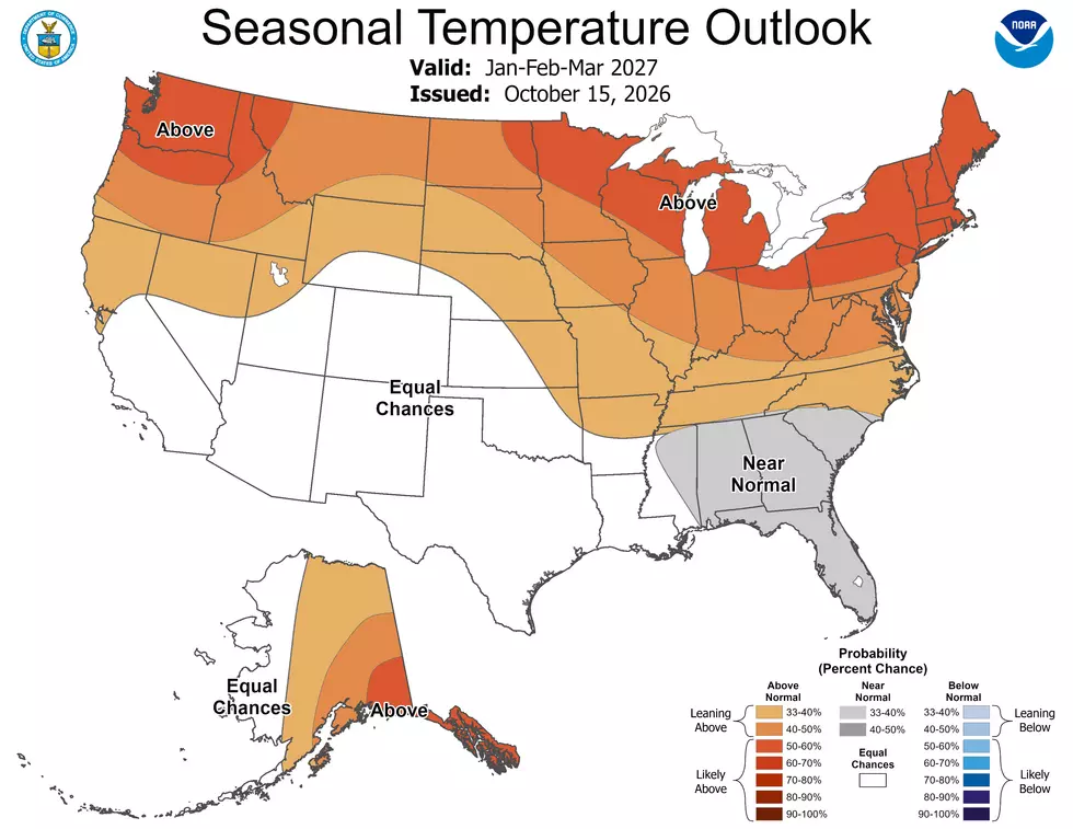
Like it or not, this one seems pretty likely: The odds are in favor of a warmer-than-normal winter across Minnesota.
The northern portions of Minnesota see the greatest odds of warmer-than-normal temperature trends through this winter, while Southern Minnesota still sees significant odds of above-normal temperatures this winter.
The thing to remember with this is that "normal" is a relative term. For example, the average temperature in January in Duluth, Minnesota might be 11 degrees. This forecast points to a likelihood of seeing a warmer average than that this winter. Not necessarily 30s or 40s all winter, just warmer than the average.
Minnesota's Winter 2026-2027 Precipitation Outlook

Precipitation is the wildcard with El Niño winters in general, and this year is no different.
Generally speaking, southern states tend to see wetter winters, while northern states tend to see less precipitation.
As the Climate Prediction Center sees things for this winter in Minnesota, there is no clear sense of the amount of precipitation, so they have most of the state in an "equal chances" category with an equal opportunity of more than average, less than average, or average precipitation amounts this winter. The only exception is far northeastern Minnesota, where there is an increased likelihood of less-than-normal precipitation.
While there is uncertainty about amounts, one thing is much clearer.
With the likelihood of warmer weather across Minnesota, we're more likely to see rain or freezing rain events more often this winter when we do get precipitation. The part that sounds the most "gross" to me in that is the freezing rain part. While you might be okay with a warm winter, nobody likes walking or driving on a glazed road or sidewalk.
Again, this is a broad brushstroke forecast, and it doesn't mean we won't see any snow, but less snow is likely, even if we do get more precipitation than normal, just because the odds of rain are greater this winter.
The 16 Least Snowy Winters On Record In Duluth History
Gallery Credit: Nick Cooper - TSM Duluth